A Winter Storm Warning is now in effect for the entire Houston area as we get closer to locking in a snowstorm [View all]
The forecast keeps moving. This morning they were predicting that most of the snow will be the east of Houston (I live to the west) and that we would get up to an inch of snow.. The latest forecast is that we make get 4 to 8 inches of snow. In 2021, we got an inch of snow and the city was shut down. BTW, neither Houston, Harris County or my county have any snowplows.
https://spacecityweather.com/a-winter-storm-warning-is-now-in-effect-for-the-entire-houston-area-as-we-get-closer-to-locking-in-a-snowstorm/
Again, just to underscore: As long as the forecast stays on track, travel is going to be nearly impossible Monday after midnight and all day Tuesday. You will almost certainly be stuck where you are until at least later Wednesday morning. The exception to this may be the far north now (like north of Highway 105), where snow may end up lighter, no ice occurs, and roads may clear off a bit after the snow stops Tuesday afternoon. But even that may be optimistic. More to come on this.
Historical context
Realistically, this is the most significant snow threat to the region since Christmas Eve 2004. The 1895 storm stands alone as the greatest on record in Texas and Louisiana, and this storm will not dethrone that one. However, with that in mind, this has the potential to set a modern official snowfall record in Houston, which currently sits at a mere 3 inches back in February 1960. January 1940 also sits at 3 inches. While a few storms since then, including Christmas Eve 2004 have produced higher amounts in parts of the area, from a record-keeping perspective, we have a chance to make some noise.
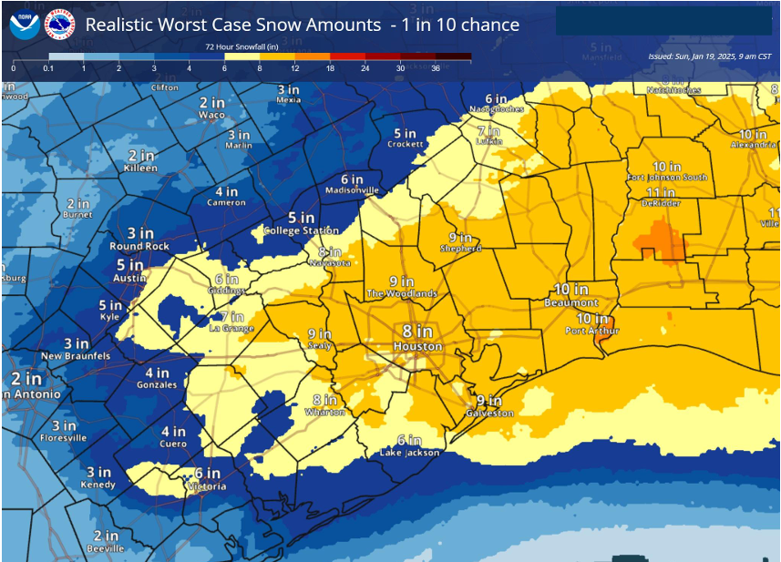
Here is the latest worse case prediction
I remember the 2021 freeze which had less than an inch of snow which was enough to shut down travel.
I have a generator which was serviced three weeks ago.
 = new reply since forum marked as read