The Bolivian Lowlands [View all]
March 28, 2023JPEG
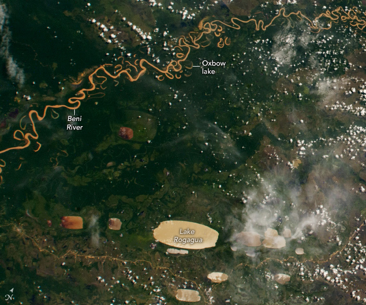
This photograph, taken by a crew member aboard the International Space Station, shows part of the Bolivian Yungas. The heavily forested ecoregion is in the lowlands of the Andes and neighbors the highlands of the Amazon rainforest.
The section of the Beni River pictured here flows northeast as it meanders across the lowlands. The sinuous river channel (brown) is juxtaposed against the vegetated floodplain (green). As it flows through the lush, topographically complex landscape, the water carries a heavy sediment load that accumulates at the river’s curves. The transport and deposition of sediment erodes the riverbank, causing remnants of the main river channel to cut off and form oxbow lakes.
The image also includes several examples of “oriented lakes” that are also known as “lagos cuadrados” (square lakes) because of their rectangular shape. Lake Rogagua is one of the largest of dozens of such lakes in central South America. The lakes, only a few meters deep, are notably oriented in the same direction with their long axes positioned northeast to southwest.
Some scientists think that the pattern relates to the dominant wind direction in South America’s recent geological past. At the time, the landscape was drier and vegetation cover was thinner or absent, which allowed winds to excavate shallow depressions in the landscape. The depressions later filled with water when the climate became wetter.
https://earthobservatory.nasa.gov/images/151450/the-bolivian-lowlands
 = new reply since forum marked as read